A) 1, in the Indian Ocean
B) 2, in Tibet
C) 3, near Japan
D) 4, near the Tonga island arc
Correct Answer

verified
Correct Answer
verified
Multiple Choice
Which of the following can cause extensive damage well after the ground shaking associated with an earthquake stops?
A) tsunami
B) fire
C) flooding from subsidence or failure of dams
D) all of these
Correct Answer

verified
Correct Answer
verified
Multiple Choice
Landslides and volcanic eruptions can cause a tsunami by:
A) causing ground shaking
B) causing large winds and fast-moving pyroclastic flows
C) causing a large mass of rock to catastrophically displace the water
D) forming large gas bubbles under water
E) heating up the water, causing it to expand
Correct Answer

verified
Correct Answer
verified
Multiple Choice
How would this diagram change if the seismic station was farther from the earthquake? 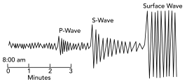
A) the P-waves would arrive later
B) the S-waves would arrive later
C) there would be a larger gap between the arrives of the P- and S-waves
D) all of these
Correct Answer

verified
Correct Answer
verified
Multiple Choice
What feature suggests that this is a strike-slip fault rather than some other kind of fault? 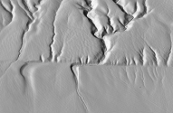
A) the presence of a fault scarp
B) the soft appearance of the landscape
C) the horizontal offset of the drainage channel
D) differences in vegetation across the fault
E) the lack of human development
Correct Answer

verified
Correct Answer
verified
Multiple Choice
When a seismic wave hits an interface and some of the energy is bent as it crosses that boundary, the wave has been:
A) refracted
B) reflected
C) defracted
D) deflected
Correct Answer

verified
Correct Answer
verified
Multiple Choice
What do the two stars near the center of this block represent? 
A) the location of the earthquake
B) the star at depth is the place where the earthquake is generated
C) the star at depth is the hypocenter
D) the star on the surface is the epicenter
E) all of these
Correct Answer

verified
Correct Answer
verified
Multiple Choice
What did geologists discover from studying the aftermath of the 1964 Alaskan earthquake?
A) some parts of the coastline were uplifted and others subsided
B) changes in elevation were not systematic, occurring randomly over the area
C) there was no good explanation for large waves that resulted from the earthquake
D) fissuring of the ground and ice was limited to an area very near the epicenter
Correct Answer

verified
Correct Answer
verified
Multiple Choice
In what order will the seismic stations #1 and #2) detect seismic waves generated by the earthquake shown in the image? 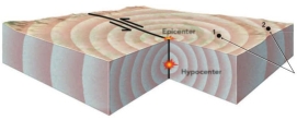
A) Station 1 will detect them first, followed by Station 2.
B) Station 2 will detect them first, followed by Station 1.
C) Stations 1 and 2 will detect the waves at the same time.
D) Only station 2 will detect waves because Station 1 is too close to the hypocenter.
Correct Answer

verified
Correct Answer
verified
Multiple Choice
Earthquakes in subduction zones generally only occur at depths of:
A) up to 700 km
B) greater than 700 km
C) 700-1000 km
Correct Answer

verified
Correct Answer
verified
Multiple Choice
On this time-travel curve, if a large earthquake is 400 km away from the station, what can you say about the arrivals of the P- and S-waves? 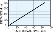
A) the P-waves will arrive 40 seconds before the S-waves
B) the P-waves will arrive 400 seconds before the S-waves
C) no S-waves will arrive at this distance from the earthquake
D) none of these
Correct Answer

verified
Correct Answer
verified
Multiple Choice
The huge 1964 Alaskan earthquake, one of the largest earthquakes ever recorded, was caused by:
A) rupture on a long segment of a strike-slip fault
B) normal faulting on an ancient fault zone in the crust
C) thrusting along a subduction zone megathrust)
D) an underwater landslide that caused a tsunami
E) a volcanic eruption on Augustine volcano
Correct Answer

verified
Correct Answer
verified
Multiple Choice
What location on the surface would provide easily gathered information about what is below the surface, without using expensive machines? 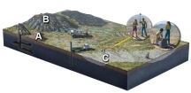
A) mine dump at A
B) mine dump at A and rocky hill at B
C) rocky hill at B and stream channel at C
D) mine dump at A and stream channel at C
E) none of these
Correct Answer

verified
Correct Answer
verified
Multiple Choice
Why did the Christchurch earthquake 2011) in New Zealand cause much more damage than the larger Canterbury earthquake 2010) ?
A) it was larger in magnitude and was deeper
B) it was closer to a large city with buildings that had been damaged by the earlier earthquake
C) a large landslide from the Southern Alps mountain range buried the capital city
D) all of these
Correct Answer

verified
Correct Answer
verified
Multiple Choice
The highest death tolls from earthquakes are generally due to:
A) people living in areas with high risks for earthquakes
B) high population densities
C) substandard construction practices
D) all of these
Correct Answer

verified
Correct Answer
verified
Multiple Choice
The time it takes for a complete wave to pass, is the:
A) wave amplitude
B) period
C) wave height
Correct Answer

verified
Correct Answer
verified
Multiple Choice
The diagram on the right shows the record of one earthquake on seismograms at three different stations in a seismic network. These three seismograms show: 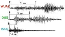
A) ISCO station is closest to the earthquake
B) WUAZ station was right at the earthquake
C) DUG station is farthest from the earthquake
D) WUAZ is the closest station, followed by DUG, and then ISCO
E) none of these
Correct Answer

verified
Correct Answer
verified
Multiple Choice
What is one way that we determine the depth to the base of the crust?
A) drilling very deep wells along the San Andreas fault
B) observing the deeper parts of underground mines
C) observing whether seismic waves that travel through the crust arrived after those that traveled through the mantle
D) using P- and S-waves to locate boundaries between molten and solid rock
E) none of these
Correct Answer

verified
Correct Answer
verified
Multiple Choice
On this map of southeastern Asia and adjacent areas, which site would have earthquakes along a mid-ocean ridge? 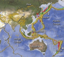
A) 1, in the Indian Ocean
B) 2, in Tibet
C) 3, near Japan
D) 4, near the Tonga island arc
Correct Answer

verified
Correct Answer
verified
Multiple Choice
Which of the following cannot cause a tsunami?
A) faulting
B) an underwater landslide
C) a volcanic eruption
D) a strike-slip fault on land
E) all of these can cause a tsunami
Correct Answer

verified
Correct Answer
verified
Showing 81 - 100 of 119
Related Exams