A) Cold Caribbean Sea waters were forced up into the north Atlantic Ocean.
B) Warm Caribbean Sea waters were forced up into the north Atlantic Ocean.
C) The ice in the Caribbean Sea was broken apart by plate movements.
D) A mountain range formed that blocked the movement of cold air into the area.
Correct Answer

verified
Correct Answer
verified
Multiple Choice
Along beaches,groins have ________.
A) solved the problem of beach drift
B) increased erosion rates immediately up current from the groin
C) increased erosion rates immediately down current from the groin
D) increased depositional rates immediately down current from the groin
Correct Answer

verified
Correct Answer
verified
Multiple Choice
Rip currents ________ the shoreline.
A) flow directly towards
B) flow directly away from
C) flow parallel to
D) are not affected by
Correct Answer

verified
Correct Answer
verified
Multiple Choice
If the wind is blowing parallel to a coast,will it create an upwelling current or downwelling current?
A) It will create an upwelling current.
B) It will create a downwelling current.
C) Neither;it will enhance the longshore current.
D) Neither;it will create a rip current.
Correct Answer

verified
Correct Answer
verified
Multiple Choice
If a dam is installed across a river,what effect will this have on the coastline?
A) It will not allow any fish to swim down the river and into the ocean.
B) It will stop the flow of water,which will lower sea level.
C) It will change the chemistry of the water and pollute the estuary.
D) It will starve the coast of sediment,and the beaches will disappear.
Correct Answer

verified
Correct Answer
verified
Multiple Choice
Using the figure below,which of the following lists correctly identifies the various seafloor landforms? 
A) A = continental shelf,B = continental slope,D = continental rise,G = abyssal plain, C = mid-ocean ridge,F = trench,and E = volcanic arc
B) B = continental shelf,A = continental slope,C = continental rise,G = abyssal plain, D = mid-ocean ridge,F = trench,and E = volcanic arc
C) G = continental shelf,E = continental slope,F = continental rise,C = abyssal plain, B = mid-ocean ridge,A = trench,and D = volcanic arc
D) A = continental shelf,B = continental slope,D = continental rise,G = abyssal plain, E = mid-ocean ridge,F = trench,and C = volcanic arc
Correct Answer

verified
Correct Answer
verified
Multiple Choice
A wave will disturb the water to a depth equal to ________.
A) its wavelength
B) its surface amplitude
C) the bottom of the seafloor
D) one-half of its wavelength
Correct Answer

verified
Correct Answer
verified
Multiple Choice
The form and topography (depth profile) of the ocean floor is termed ________.
A) orogeny
B) bathymetry
C) allocthony
D) aquitopography
Correct Answer

verified
Correct Answer
verified
Multiple Choice
If sea level continues to rise and covers the city of Miami,the Florida coast will become a(n) ________.
A) emergent coast
B) submergent coast
C) continental slope
D) abyssal plain
Correct Answer

verified
Correct Answer
verified
Multiple Choice
Which type of coastline would most likely contain estuaries or fjords?
A) a subductive coastline
B) an emergent coastline
C) a submergent coastline
D) a divergent coastline
Correct Answer

verified
Correct Answer
verified
Multiple Choice
How would the Coriolis affect the space station?
A) The space station would curve to the right because it is above the northern hemisphere.
B) The space station would curve to the left because it is above the southern hemisphere.
C) The space station would not curve because it is above the equator and not affected.
D) The space station would not be affected because it is not in Earth's atmosphere.
Correct Answer

verified
Correct Answer
verified
Multiple Choice
Barrier islands are constantly moving in the direction of ________.
A) the longshore drift
B) the high tide
C) downwelling
D) the Coriolis effect
Correct Answer

verified
Correct Answer
verified
Multiple Choice
The density of seawater increases with ________ temperature and ________ salinity.
A) increasing;increasing
B) decreasing;increasing
C) increasing;decreasing
D) decreasing;decreasing
Correct Answer

verified
Correct Answer
verified
Multiple Choice
You are a coastal geologist trying to help a coastal community restore its sediment-starved beach.You decide that beach nourishment is the best option,so you order that dredge sediment from the nearest river be placed on the beach.The sediment is 70% silt and 30% sand.What will be the effect of using this sediment?
A) The silt will be washed away by the waves,leaving the beach no better off.
B) The sand will be washed away by the waves,but the silt will fix the problem.
C) All the sediment will remain on the beach and will fix the problem.
D) All the sediment will remain on the beach,but it will become muddy and filthy.
Correct Answer

verified
Correct Answer
verified
Multiple Choice
Thermohaline circulation carries ________ water from the poles to the equator,where the water becomes ________.
A) warm;cold
B) cold;warm
C) low density;more dense
D) low density;more salty
Correct Answer

verified
Correct Answer
verified
Multiple Choice
Which of the following figures shows a coast experiencing high tide? 
A) A
B) B
C) C
D) D
Correct Answer

verified
Correct Answer
verified
Multiple Choice
The U-shaped valleys in Kenai Fjords National Park in Alaska were created during a(n) ________.
A) transgression
B) regression
C) flooding event
D) undersea landslide
Correct Answer

verified
Correct Answer
verified
Multiple Choice
The deepest segments of the ocean floor are found ________.
A) along mid-ocean ridges
B) in the geographic centers of abyssal plains
C) in trenches associated with passive margins
D) in trenches associated with subduction zones
Correct Answer

verified
Correct Answer
verified
Multiple Choice
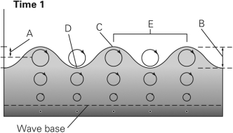
In the figure below,which letters represent the crest and trough? 
A) A and B
B) E and D
C) C and D
D) C and B
Correct Answer

verified
Correct Answer
verified
Multiple Choice
The sea surface salinity is ________ at the mouth of the Amazon River and ________ in the Dead Sea.
A) low;low
B) high;low
C) low;high
D) high;high
Correct Answer

verified
Correct Answer
verified
Showing 21 - 40 of 50
Related Exams